PLEASE GO TO OUR NEW WEBSITE, WHICH IS: http://handsacrossthelake.com/

Home | About Us | History/Background | Recent and Upcoming Events | Getting Involved | Newsletter Archive Page | Newsletter Page | Photo Album | Contact Us | Entertainment Card Benefits HAL | Summer Camp Photos 2002 | Press Releases | Hot Issues | New Report: Impact of Runoff Pollution | New page title

Welcome to the website for Hands Across The Lake Edit
About Us | History/Background | Recent and Upcoming Events | Getting Involved | Newsletter Archive Page | Newsletter Page | Photo Album | Contact Us | Entertainment Card Benefits HAL | Summer Camp Photos 2002 | Press Releases | Hot Issues | New Report: Impact of Runoff Pollution | New page titleEdit

Who Are We? Edit

Hands Across The Lake is an organization in Midlothian,Virginia (20 miles south of Richmond, VA). It is a community effort to promote the health and life of the Swift Creek Reservoir, preserving it as a source of good drinking water and as a beautiful recreational source.


Edit

Swift Creek Reservoir at Sunset
sunsetatswiftcreek.jpg
Water is too precious a gift to ignore Edit

Members of this organization monitor commercial and residential activities within Chesterfield County that may impact on the well being of the reservoir and share the information with the community. They also sponsor meetings and distribute literature to help educate the community on conditions affecting the reservoir Edit

Mission Statement Edit

To preserve the Swift Creek Reservoir as a major source of drinking water for Chesterfield County. To inform and educate residents about the status of the Swift Creek Reservoir watershed in Chesterfield County. To promote cooperative actions between residents and their governing bodies to maintain the health of the Swift Creek Resrvoir.

Edit

WOODLAKE SHOPPING PROJECT USING NEW TECHNOLOGY TO PROTECT THE RESERVOIR

HAL is supportive of the recent engineering and extra environmental measures taken to protect the reservoir from the run off of Woodlake Commons Shopping Center, a 24 acre commercial site. If successful, the project could serve as a model for future projects.

The new shopping center project at the entrance to Woodlake will be built on a 23.7 acre tract of land just west of Woodlake Village Parkway at Hull Street Road.

The tract is environmentally sensitive because of its proximity to the reservoir. The property has very steep slopes which can generate excess runoff during construction. To compensate, the county required extra measures be used to prevent sediment and phosphorus from entering the reservoir:

1. The project is split into four separate sequences or phases of

construction. This is designed to minimize the amount of land disturbed at any one time. The start of the next phase requires completion of the previous phase.

2. The project will utilize two oversize sediment basins on the construction site to capture the run off and treat it. These basins are 25% larger than the minimum required by state code.

3. Anionic PAM is utilized to coagulate the small sediment particles into larger ones to make the environmental barriers work near 95% efficiency.

[Note: Based on positive experience in other states, HAL has been an avid promoter of the use of this PAM in the watershed to get clean water.]

4. Extra environmental measures are required for critical areas. The project uses double silt fencing, environmental fabrics to hold seed in place for stabilization, mulch treated with PAM over a jute mesh etc.

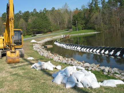
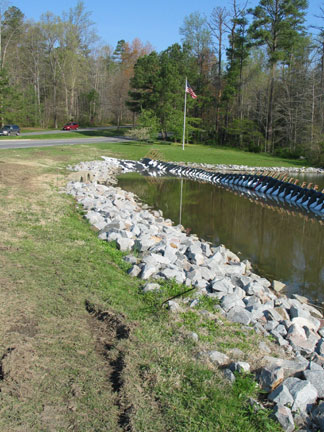
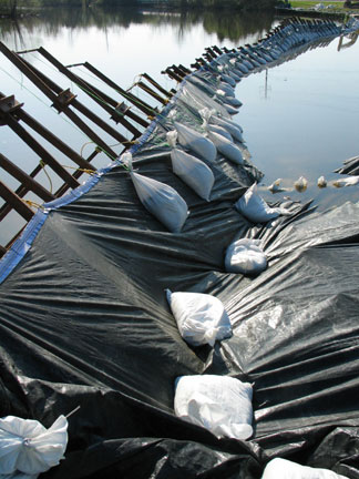
5. If all these measures fail, then any silt laden runoff will be captured by the fenced off section of the reservoir around the inlet culvert that runs under Woodlake Village Parkway. Attached photos #1 and #2 show a general view of this area; photo #3 shows details of the filter fabric for the dam. The plan is to remove any sediment captured in this section before the dam is removed. 

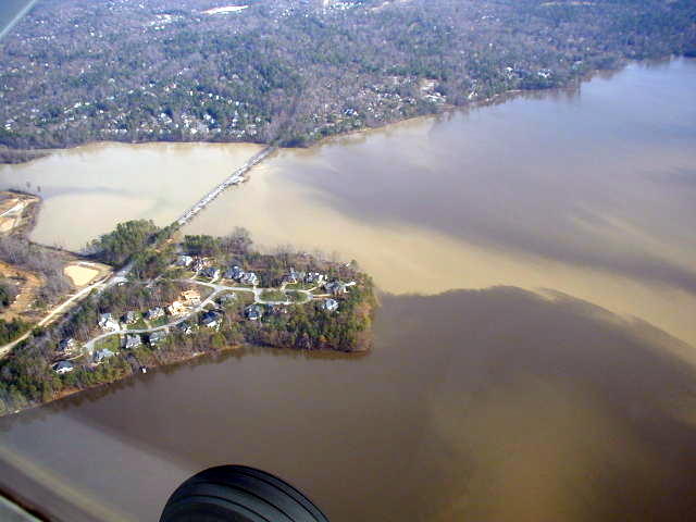
 Photo # 4 was taken in December 2003 at the opposite end of the reservoir and shows what can happen when inadequate measures are taking to prevent soil erosion during construction.

Edit

April 2004
woodlakebarrier1.jpg
Final Barrier for Woodlake Shopping Center Project Edit

Photo #2
woodlakebarrier1a.jpg
Edit

Photo 3
woodlakebarrier2.jpg
Edit

Photo 4: Genito Road, December 2003
genitodec03.jpeg
Edit

Reservoir Facts
 
Size: 1700 acres
Average Depth: 8.11  feet
Length of Shoreline: 8 miles
Largest drinking water source in county

Tips For Environmentally Friendly Lawn Care

Click Here for information on native plants

Click here for information on invasive plants

Click here to reach Chesterfield County Board of Supervisors

Click here to reach the Chesterfield County Planning Department

Click here for information on "Friends of Chesterfield's Riverfront"

Click here for information on the Sierra Club